Pressemitteilung —
Euro-Maps 3D DSM now also available via the Copernicus Data Access Portfolio
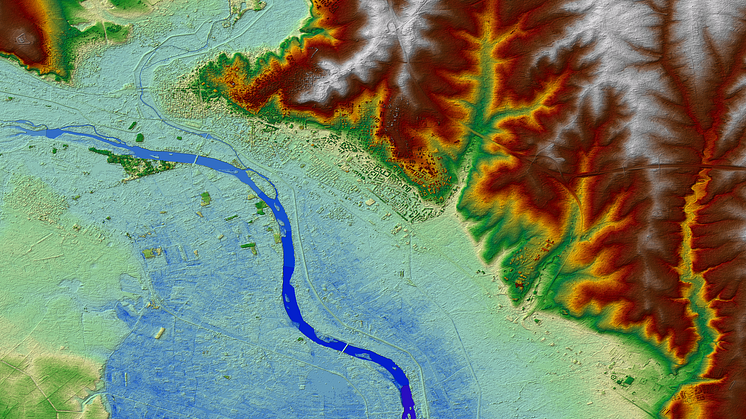
ESA, the European Space Agency, has added the Euro-Maps 3D DSM (digital surface model) product with 5 m post spacing to the Copernicus Data Access Portfolio (DAP) (see latest DAP document, Annex 6), thus making it available to Copernicus Services, Union Institutions and Union Research Projects through the Copernicus Data Warehouse (DWH). Euro-Maps 3D DSM provides a homogeneous quality, particularly suitable for large-scale, trans-national applications such as hydrologic modelling, infrastructure, network planning, risk mapping and the exploration of natural resources.
With the adding of the Euro-Maps 3D DSM product to the Copernicus Data Access Portfolio (DAP) by ESA, Copernicus Services, Union Institutions and Union Research Projects can now use the high resolution DSM data to apply it for e.g. hydrologic modelling, infrastructure, network planning, risk mapping and the exploration of natural resources – thus improving various planning and disaster risk management activities. ESA’s latest addition follows a successful assessment phase conducted by the Risk & Recovery component of the Copernicus Emergency Management Service (CEMS).
Euro-Maps 3D DSM – a homogeneous, reliable and precise digital surface model
The Euro-Maps 3D DSM product comprises a digital surface model (DSM) with 5 m post spacing and an (optional) associated ortho layer with a 2.5 m spatial resolution. Both components are derived from stereo image pairs acquired by the Cartosat-1 satellite at an original 2.5 m spatial resolution. The fully complementary, seamless 2.5 m resolution panchromatic ortho layer is based on the near-nadir images of the Cartosat-1 stereo pairs, automatically stacked according to various criteria, including their cloud cover and sun elevation.
For Europe, the product is based on stacks of up to 15 stereo pairs. The use of multiple stereo pairs acquired using different acquisition angles leads to the minimization of gap-filling areas and results in unique accuracy and reliability. During an editing process, the DSM is further refined and water bodies exceeding certain dimensions are hydrologically corrected, so that consistent water flow is ensured. Detailed quality and traceability layers are part of the delivery and every height value can be traced with pixel accuracy.
The product is processed for most of the territory of the EEA member and associated countries. For the production, a highly automated processing chain developed in close co-operation with the German Aerospace Center (DLR) is being used.
The Euro-Maps 3D DSM is part of the GAF Elevation Suite, which comprises also Euro-Maps 3D for Ortho products with 10 m post spacing and VHR multi-stereo DSM products. For further details about Euro-Maps 3D, please see http://euro-maps.gaf.de/products/prod_008.html.
Links
Themen
Kategorien
About GAF AG: www.gaf.de
GAF AG is an e-GEOS (Telespazio/ASI) company located in Munich and Neustrelitz, Germany. It is a leading geo-information company with an international reputation as a skilled provider of data, products and services in geo-information, spatial IT and consulting for private and public clients. GAF is the exclusive supplier in Europe of optical Indian Remote Sensing satellite (IRS) data from several missions. The company’s archives contain systematic coverages of Europe and northern Africa from the high and medium resolution IRS missions IRS‑1C, IRS-1D, Resourcesat-1, Resourcesat-2 and Cartosat‑1 since 1996. GAF specialises in the production of ortho-image mosaics and digital elevation models from various high and very-high resolution satellite missions.