News —
New Skies for Yamaha’s Unmanned Helicopters Yamaha Motor Newsletter (October 11, 2019 No. 75)
Since around 2015, the commercial drone business has grown rapidly on a global scale and is expected to further expand going forward. Today, remotely operated or autopilot-equipped Unmanned Aerial Vehicles (UAVs) fitted with cameras or surveying devices are used for aerial photography and filming, observation and measurement of landforms and construction sites, and for transporting packages.
Yamaha Motor is a pioneer in this industry, having successfully commercialized an industrial-use unmanned helicopter in 1987. In the more than 30 years since, Yamaha’s unmanned helicopters have secured a proven reputation in crop dusting and other applications, and we are leveraging our highly refined hardware and know-how from the field toward providing a diverse range of other aerial solutions.
With the drone business booming, Yamaha is actively pursuing avenues to bring its unmanned helicopters to new skies.
A Heavy Payload, Proven Reliability and Powerful Performance Acquired through Aerial Agriculture
Many of the drones used for commercial purposes today are powered by electric motors driving multiple helicopter rotors. There are also various sizes, with the more compact models fitting into two hands and larger models reaching some two meters in length or width. However, Yamaha’s industrial-use unmanned helicopters are approximately 3.5 meters long and feature a single rotor powered by a gasoline engine, giving them a heavy payload and a long flight time.
Yamaha first began developing unmanned helicopters in 1983 when an external organization of the Ministry of Forestry, Agriculture and Fisheries requested a remotely operated aerial vehicle for spraying agrichemicals. Japan’s agriculture workforce was already beginning to age and shrink at the time, and this request was to substantially reduce the time and labor required to spray crops with agrichemicals during Japan’s humid summers.
However, Yamaha’s first prototypes with counter-rotating coaxial rotors did not offer the required levels of controllability, stability, payload and more. So, the decision was made to switch to a more conventional single-rotor design like those used by radio-controlled models, and Yamaha’s first unmanned helicopter model, the R-50, was completed in 1987. Carrying 10 liters of agrichemicals, it could spray a 1-hectare field in just 10–15 minutes, a whopping 16 times faster than a person trudging through the same field on foot carrying a heavy tank and spray hose. The R-50 made pest control a much easier affair for Japanese farmers.
Making a capacity of 8 liters to spray 1 hectare in 10 minutes the standard, Yamaha then introduced several updates with subsequent models to carry more fuel and agrichemicals to make it easier to spray wider areas and multiple neighboring fields more efficiently. The workhorse of Yamaha’s lineup today is the FAZER R, which features a 32-liter payload. It can operate for about 25 minutes in a single flight and is capable of spraying 4 hectares—four times as much as the original R-50. Carrying on two features unique to Yamaha’s lineup, the powerful downwash from the main rotor provides a uniform application of agrichemicals while the spray apparatus also ensures the chemicals reach the roots of the crop. For Yamaha, it’s not just about spraying the crop; it’s also about how to dispense the spray effectively as well as efficiently. This dedication to real-world use and quality is the result of our years of experience and know-how.

Yamaha’s industrial-use unmanned helicopters are designed for high efficiency, with the rotor’s downwash uniformly dispersing agrichemicals and ensuring they reach crop roots.
Enhancing Versatility with Electronic Control and Automatic Flight
The bedrock of Yamaha’s unmanned helicopter business remains in agriculture. In Japan, thousands of these helicopters are at work in the sky with more than 10,000 licensed operators. One of the reasons for their widespread acceptance is their ease of use. In 1995, fiberoptic gyros were utilized to develop the revolutionary Yamaha Attitude Control System (YACS), which featured an operator-controlled model-tracking device to more faithfully respond to steering commands. Introducing YACS made the helicopters easier to operate and greatly improved safety.
Then, following the release of the RMAX in 1997, advanced technologies like GPS and various sensors were actively introduced on the aircraft, dramatically improving the precision of electronic control. Yamaha then began developing technologies to automate and simplify certain precision control operations while creating a way to preprogram the helicopter for fully automated flight. In 2000, the RMAX gained national attention when it flew automatically beyond the range of human sight to observe the eruption of Mt. Usu in Hokkaido.
This led Yamaha to use its industrial-use unmanned helicopters equipped for automatic flight to observe volcanic activity at Shinmoedake and the islands of Miyakejima, Sakurajima, Kuchinoerabujima and Nishinoshima, and to observe, survey, film and photograph various natural disaster sites. Yamaha is currently putting this extensive experience and know-how toward expanding its solutions business for numerous fields, but at the same time, we introduced the FAZER R G2 in 2016. This new platform better caters to a wide range of uses and features a 35 kg maximum payload, 2,800 m service ceiling and 90 km range.
In recognition of the development of attitude/speed control systems and the automatic flight system that subsequently led to the pioneering use of unmanned helicopters in agriculture and natural disaster response, a Yamaha engineer on the joint-development team was awarded the Commendation for Science and Technology in April 2019 by the Minister of Education, Culture, Sports, Science and Technology in Prizes for Science and Technology (Development Category).

Yamaha unmanned helicopters can approach the mouth of a volcano in airspace restricted for manned aircraft, transmitting video and still images in real-time. The photo shows an RMAX G1 conducting observation work near the Nishinoshima volcano in 2015.
Bringing Unmanned Helicopters to New Commercial Applications
More than sales of the aircraft itself or its associated equipment, the commercial drone market in recent years is seeing particularly strong growth in providing services, from crop dusting and photography/filming to surveys/observation and logistics. While continuing sales of models meant for agriculture, Yamaha has also formed a team of solution specialists dedicated to services beyond farming and is beginning to pursue several new uses for unmanned helicopters.
One such service is the transport of construction materials. In Japan, transporting materials by truck for construction or maintenance on electrical transmission line towers located in remote mountain areas has been an ongoing challenge for power companies. In a 2017 field test using a FAZER R G2 equipped for automatic flight, the helicopter successfully carried the necessary materials from the stockyard at the bottom of the mountain to the construction site at the summit. Capable of carrying up to 26.5 kg in one flight, the FAZER R G2 transported an incredible 672 kg of materials per day. Efforts were then made to further augment safety and transport efficiency, and aerial transport services using Yamaha unmanned helicopters officially began in 2019.
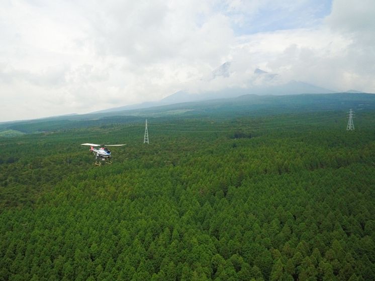
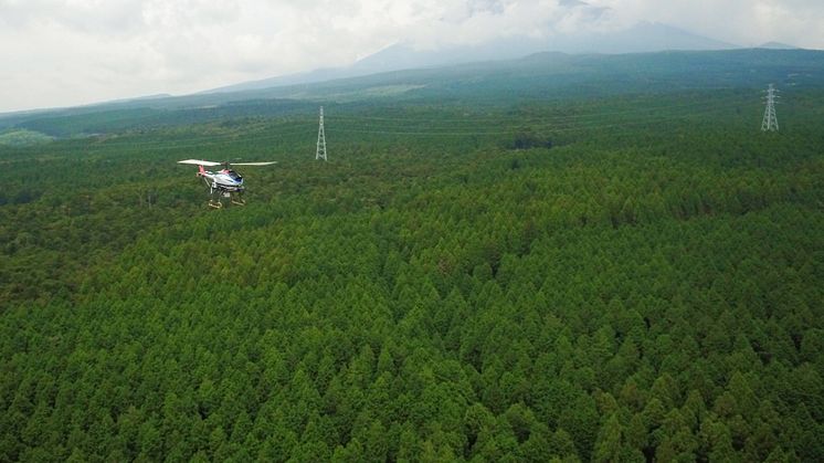
Another new business opportunity Yamaha is pursuing with its helicopters is forest surveys. Almost 70% of Japan’s land area is forested and since ancient times, wood has been the primary building material for homes, household goods, tools and more. However, private owners of forested land typically have small, dispersed holdings, and factors like new generations of owners and a protracted slowdown in the forestry and logging industry have led to more cases of improper upkeep or no planting of new trees.
To address these problems, the government established a forestry management scheme based on new laws. This clarifies who is responsible for maintenance with a forest ledger, and forests that cannot be managed are integrated with the forests of capable owners, or the local government takes over management to properly maintain the forest. This was done to help drive initiatives that raise the value of the forests.
To facilitate these activities, what is needed first is to gauge the current condition of large forest areas with accuracy and detail, like property boundaries and how many of what species of tree there are. Recently, remote sensing equipment and LiDAR have seen much greater use with airplanes and drones, and technology now allows people to walk through forests with backpack laser scanners and then create 3D images based on the data. These technological advances brought efficiency improvements to forestry tasks, which heavily relied on conventional aerial photography and manual methods.
“We mounted a LiDAR capable of scanning approx. 600,000 points per second on our FAZER R G2 for automatic flight. Flying at low speeds, it provided a unique high-density measurement of forest conditions with 20 times greater accuracy and precision than a manned aircraft,” says the General Manager of the Planning Division at Yamaha’s New Venture Business Development Section. “And because it can fly without needing to land for an hour and a half, which is about three times longer than the electric multi-rotor drones from our competitors, it can efficiently survey large areas of forest for a lower cost per unit area.” After conducting extensive testing for years prior, Yamaha received a request in 2018 from a body involved with the Ehime Prefecture Forestry Promotion Group and worked with a company to co-develop a system for detecting area delineations for forest management.
Then in August 2019, Yamaha collaborated with Fuji City in Shizuoka Prefecture and other organizations in a field test to survey the conditions of 12,000 hectares of forest around Mt. Fuji. “We still aren’t able to analyze the data we get, but I think we’ve reached a stage now where we can conduct a survey and provide all the measurements and data needed,” continues the General Manager. “We’re now drawing up specific plans to present to local governments and other bodies to launch this as a new business next year.”
In the same way Yamaha aims to improve the efficiency and quality of its crop-dusting operations, we are focusing on conducting efficient forest surveys that provide accurate, high-density data to deliver service that surpasses client expectations. At the same time, this new venture contributes toward the sustainability of a vital resource and maintaining Japan’s beautiful forests in perpetuity. This is the business style of the
Kando*
Creating Company that Yamaha Motor aspires to be.
* Kando is a Japanese word for the simultaneous feelings of deep satisfaction and intense excitement that we experience when we encounter something of exceptional value.
|
|
|


The FAZER R G2 is equipped with a satellite link for remote operations in areas radio waves cannot reach and an automatic flight system. Mounting a high-performance LiDAR allows it to conduct high-density surveys that go below the forest canopy.
FAZER R G2 Aerial Solutions Video (YouTube: in Japanese only)

|
Message from the Editor Our industrial-use unmanned helicopters boast a much greater payload and flight time than electric multi-rotor drones, and we unveiled a next-generation concept model at CES in 2019 that takes those advantages to the next level. Also, as part of our efforts in Africa introduced in our previous issue, a joint field test is set to start in December 2019 with an industrial drone service company in Kenya using the FAZER R G2—watch this space.
Yamaha Motor signed a formal partnership with Kenya’s Astral Aerial Solutions in August at the 7th Tokyo International Conference on African Development (TICAD). Naoto Horie |